A practical planning guide
How to Use Buggin With TroutRoutes
Find the water with TroutRoutes. Read the water with Buggin.
Start with the decision
Find the water. Then read the water.
A fly-fishing trip often starts with two separate questions. The answer to one does not automatically answer the other.
TroutRoutes
Where should I look?
Discover trout streams, understand access, and plan the route.Buggin
What is that water doing?
Interpret conditions, hatches, flies, tactics, and likely windows.Go fish
Choose the water, timing, and approach.
Confirm access, regulations, weather, and conditions before you leave.TroutRoutes specializes in trout stream discovery, mapping, access, and trip planning. Buggin focuses on interpreting fishing conditions, expected hatch activity, flies, tactics, and fishing windows. Because they emphasize different parts of trip planning, Buggin and TroutRoutes can be useful together.
The map and access plan
What TroutRoutes is especially good at
TroutRoutes brings the practical geography of a trout trip into focus, especially when you are exploring unfamiliar water.
- Discovering trout streams and sorting them with stream classifications and filters
- Reviewing public-access context, fishing easements, bridges, trails, parking, and other trip logistics
- Researching a stretch, saving personal map content, and getting directions to map features
- Downloading map regions for offline use with TroutRoutes Pro
- Checking stream-gauge information and real-time stream conditions where available
Feature descriptions are based on TroutRoutes’ official FAQ and user guide. Offline maps and real-time stream conditions are described as Pro features in those materials.
The current conditions read
Where Buggin fits
Once you know what water you might fish, the questions become more immediate: which river looks best today, when should you go, and how should you start?
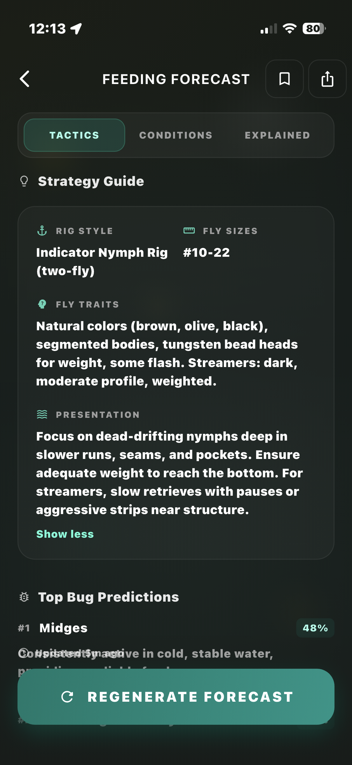
Buggin is designed around that next layer of the plan. It brings together streamflow and trend, water temperature where a reliable reading is available, weather, expected hatch activity, likely fly patterns, tactics, estimated fishing windows, saved waters, alerts, and an overall fishing outlook.
- Which river looks most promising among the waters you can realistically reach?
- Is the flow rising, falling, or stable—and what might that mean for your plan?
- What insects and fly patterns are likely worth having ready?
- Should morning, afternoon, or evening get more of your attention?
- Which tactics make sense as a starting point for the conditions?
Buggin is decision support, not a crystal ball. Conditions change, sensors have limits, and fish always get the final vote. Use the outlook as a better first plan, then pay attention on the water.
Explore live forecasts
Start with the waters you already know.
Browse Buggin's forecast directory, then compare a few candidate rivers before you burn gas.
Put the two together
The TroutRoutes + Buggin workflow
Start with the part of the trip that is still uncertain. The sequence below is a practical way to move from a broad idea to a more considered fishing day.
- 1
Scout the area in TroutRoutes
Find accessible trout water, understand land ownership and access context, and narrow down possible spots.
- 2
Build a shortlist
Choose two to four realistic waters based on location, access, and the type of fishing you want.
- 3
Check them in Buggin
Look at conditions, flow trends, temperature where available, weather, expected hatch activity, likely flies, tactics, and fishing windows.
- 4
Compare your options
Decide which water currently looks most promising for the time you actually have.
- 5
Plan the approach
Use Buggin's guidance to think through timing, flies, and tactics before you get to the river.
- 6
Confirm before fishing
Always verify access, current regulations, closures, weather, and relevant agency information before heading out.
A realistic weekend
Example: planning a southwest Montana day
You have a weekend near southwest Montana, several trout rivers within driving distance, and no interest in gambling on a long drive to water that does not fit the day.
First: map the practical options
Use TroutRoutes to find the waters that make sense.
- What trout water is nearby?
- Where is public access?
- Which stretches fit the trip and the available time?
- Where can you park or enter?
Then: compare the day's signals
Use Buggin to read the shortlist.
- Flow and trend
- Water temperature where available and weather
- Expected hatch outlook and fishing windows
- Likely flies and tactics
The final choice comes from both sides of the decision: where you can realistically fish and what the water appears to be doing that day. This is a hypothetical planning example, not a claim about current conditions on any specific river.
Choose the tool for the question
Do you need both apps?
Not necessarily. The right tool depends on the gap in your own planning process.
Start with TroutRoutes when
“Where can I legally fish?” is the main question.
It may be the more important tool when you are learning a new area, looking for access, or building a route around unfamiliar trout water.
Start with Buggin when
“How is this water likely fishing today?” is the main question.
It may be more directly useful when you already know where you are headed and want a conditions-first plan for timing, flies, and tactics.
If you often explore unfamiliar water and also care heavily about current fly-fishing conditions, the two apps can work particularly well together. No one needs every tool for every trip.
Common questions
Buggin and TroutRoutes FAQ
Can I use Buggin with TroutRoutes?
Yes. TroutRoutes can help you find trout water and understand access. Once you have a few waters in mind, Buggin can help you compare current conditions, expected hatch activity, likely fly patterns, tactics, and fishing windows. The apps are separate and do not need to be linked to use them this way.
Is Buggin a TroutRoutes alternative?
They emphasize different parts of a fishing trip. TroutRoutes specializes in trout-stream discovery, mapping, access, and trip planning. Buggin focuses on interpreting fishing conditions, expected hatch activity, flies, tactics, and fishing windows.
What is the difference between Buggin and TroutRoutes?
TroutRoutes answers questions about where to look and how to get there. Buggin helps answer what the water may be doing today and how you might approach it. Both can be useful when you are planning an unfamiliar trout-fishing day.
Which app is better for finding trout streams?
TroutRoutes is the more direct choice for discovering trout streams, reviewing map layers, and researching access. Its official materials describe classified trout streams, public-access context, filters, directions, and offline maps for Pro users.
Which app is better for current fly-fishing conditions?
Buggin is built around a fly-fishing conditions read: flow and trend, water temperature where available, weather, expected hatch activity, likely flies, tactics, and estimated fishing windows. These are decision-support signals, not a promise of fishing success.
Does TroutRoutes show river flows?
TroutRoutes says its Pro experience includes real-time stream conditions and stream-gauge information. Check TroutRoutes directly for current coverage and plan-specific availability.
Does Buggin show hatches and fly recommendations?
Buggin presents expected hatch activity alongside likely fly patterns and tactics. Conditions and insect activity can shift, so use the forecast as a starting point and adjust to what you see on the water.
Can I use both apps on the same fishing trip?
Yes. A common sequence is to use TroutRoutes for the map and access plan, then use Buggin to help choose among your realistic options and prepare your timing, flies, and tactics. Always confirm access, regulations, weather, and closures before you go.